Weather
Weather Update as of 12/19/22
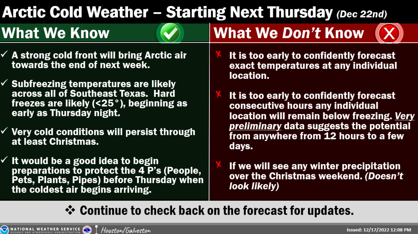
- The approaching arctic air outbreak will be the coldest air mass since February 2021.
- It is forecast that temperatures will drop quickly Thursday Night into Friday Morning.
- Temperatures likely to be in the teens north of Highway 105, near 20 degrees near I-10, and in the mid 20s south of I-10
- Many areas could be below freezing for 20-36 hours
- Many areas will likely not get above freezing on Friday.
- Though warming into the upper 30s will occur on Saturday, temperatures will drop below freezing on Saturday Night/Sunday Morning
Important to Protect the Four Ps
Cold weather can pose a danger to the health and safety of Houston residents, and proper care should be taken to reduce your exposure to these conditions. When cold weather occurs, Houstonians should remember to protect People, Pets, Pipes, and Plants.
People
- Dress in warm clothing, wear gloves, coats and layers when you’re outside.
- Never leave children or the elderly in vehicles during cold weather, as they act as a refrigerator and can result in sub-freezing temperatures.
- Never use a generator, grill, camp-stove or any gasoline, propane, natural gas or charcoal-burning device to heat your home (or any enclosed area). This can generate carbon monoxide, which cannot be seen or smelled, but is deadly.
Pets
- Protect your pets by ensuring that they have a warm, safe place to sleep. The best place for a dog or cat is to sleep in a heated environment.
- Be sure not to shave your dog down to the skin in winter, as a longer coat will provide more warmth.
- Never leave your animal in a car during cold weather. Cars can cat as refrigerators in the interior, holding in the cold and causing animals to freeze to death.
Pipes
- Protect pipes from freezing by leaving them on a small, slow drip during the freezing hours.
- Open lower cabinet doors to expose pipes to the warmth of the home.
Plants
- Protect plants from freezing by covering them with plant-cover fabric, or a light blanket with plastic sheeting on top of it.
Be sure to group plants that are in containers together, and near your home. Remember that soil in containers can get just as cold as the air temperature, and cause the roots to freeze, even if the above-surface leaves survive.
National Weather Service Information
- Thursday into the Christmas Holiday
- The Arctic front is on track to move into the area on Thursday. It will bring periods of freezing temperatures (and likely some <25°) into much of the weekend.
- Too early to confidently pinpoint exactly just how low readings will fall, or how many consecutive hours below freezing any single location will get.
- Confidence is high that we will see some bitterly cold air and freezing temperatures, but don’t focus on any individual model, or model run, this far out.
- The specifics will change as time progresses.
- All businesses and residents should begin preparation for some hard freezes before the coldest weather is set to move in on Thursday.
- For industry that needs an extended amount of lead time, the NWS encourages individuals to review plans/actions that might need to be implemented should conditions warrant (any extended durations of subfreezing temperatures, gale force winds, high seas, low water conditions, etc.)
Notice Regarding Extreme Weather Emergencies
This communication is to notify you that Heatherloch Municipal Utility District, your retail water and sanitary sewer provider, is:
- prohibited from imposing late fees or disconnecting retail water or sewer service for nonpayment of bills that are due during an extreme weather emergency until after the emergency is over;
- required to offer a payment schedule to a customer who requests such a schedule for unpaid bills due during an extreme weather emergency; and
- prohibited from disconnecting retail water or sewer service for nonpayment of bills due during an extreme weather emergency until after a payment schedule has been offered and the customer has either declined to accept the payment schedule in a timely fashion or violated the terms of the payment schedule.
For purposes of this communication, an “extreme weather emergency” is defined as a period beginning when the previous day’s highest temperature in an area did not exceed 28 degrees Fahrenheit and the temperature is predicted to remain at or below that level for the next 24 hours according to the nearest National Weather Service reports for that area. An extreme weather emergency is over on the second business day the temperature exceeds 28 degrees Fahrenheit.
Aviso Sobre Emergencias Climáticas Extremas
Esta comunicación es para notificarle que su proveedor de agua y alcantarillado sanitario Heatherloch Municipal Utility District es:
- prohibido imponer cargos por demora o desconectar el servicio de agua o alcantarillado por falta de pago de las facturas que vencen durante una emergencia climática extrema hasta después de que termine la emergencia;
- obligado a ofrecer un plan de pago a un cliente que solicite dicho acuerdo para las facturas adeudadas durante una emergencia climática extrema; y
- prohibido desconectar el servicio de agua o alcantarillado por falta de pago de facturas adeudadas durante una emergencia climática extrema hasta que se haya ofrecido un plan de pago y el cliente se haya negado a aceptar el plan de pago de manera oportuna o haya violado los términos del plan de pago.
A los fines de este comunicado, una “emergencia climática extrema” se define como un período que comienza cuando la temperatura más alta del día anterior en un área no superó los 28 grados Fahrenheit y se pronostica que la temperatura permanecerá en ese nivel o por debajo de este durante las próximas 24 horas. de acuerdo con los informes del Servicio Meteorológico Nacional más cercano para esa área. Una emergencia climática extrema termina el segundo día hábil en que la temperatura supera los 28 grados Fahrenheit.


